I initially thought that Yoho National Park was about 7 hours away from Edmonton. So we decided to stay a full week in the area so we can do everything we wanted to do. It turns out it was only a 5 hour drive. I found out a week before the trip when I finally googled directions. At which point, everything for the week was pretty much set. But anyway, I'm glad we stayed for the entire week as it really gave us the chance to explore the area.
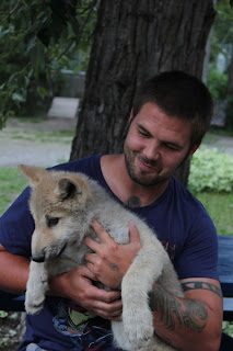
After Lake O'Hara, the second leg of our trip was Golden, BC. There's a wolf sanctuary there that Steve's been dying to go to since I met him. But since we thought it was an 8 hour drive, the trip never became a priority. The wolf sanctuary was pretty neat. We got to meat the wolf pack that was comprised of mostly rescue wolves. All of them were raised in captivity, not by the owners' doing. Most of them were orphaned at a very young age and a couple were 10% part dog which some people bred them to be pets but decided eventually that their wolf side was a little bit too much to handle once they got older. There were a couple of little orphaned wolf cubs that were at the center when we visited, and we got to hold them and take pictures with them.
This little one tried to eat my arm. They are very young though, so it didn't hurt. But it was quite amusing seeing him attempt to eat me.
After that, we just walked around town a little bit. We were both fairly tired from hiking and having to deal with the rain in the backcountry from the past four days, that we really just wanted to chill. We also missed watching television quite a bit.
After a couple of days in Golden, we headed back to Yoho National Park on Thursday morning to spend a couple of nights in Takakkaw Falls to do the Iceline Trail circuit and boulder for the first time outdoors. We were initially going to boulder on our first day out there, but when we picked up a map at the visitor center, the dude there suggested that if we wanted to do the Iceline trail, we should try to do it that day. Thursday had really gorgeous weather, and Friday was forecasted to have some rain with some chance of thunderstorms. He said it wouldn't be a good idea to be up on the Iceline trail on a downpour. So, we took his advice and headed out to the campground to set up as fast as we can so we can head out.
The campground was really nice. It was set up like a backcountry campground, yet it's still front country. They are walk-in campsites, so you're only 500m away from your car. They have little wagons there to help people load their crap from their car to camp. Most of the sites had a really good view of Takakkaw Falls. It was really nice to sleep with the sound of the waterfalls in the background and seeing it first thing in the morning when you wake up.
Anyway, we didn't finish setting up camp till almost 3pm, but we didn't want to miss out on doing the Iceline trail in the event the weather turns on us again the following day. There are three options you can take when doing the Iceline trail. The shortest one is a 12km in-and-out the same way type deal, the second one is 17km circuit that takes you down to Lake Celeste and Laughing Falls, and the last one is an even longer circuit that leads you to Little Yoho Valley. Iceline's elevation gain is approximately 700m, it was fairly steep, and the shortest option was estimated to take about 5-6 hours. Since we didn't have much time, we decided to just do the shortest option, and maybe try to do the rest of the circuit from the other direction if the weather isn't so bad the next day. Since it's in a lower elevation, we figured it might be okay in the rain.
The Iceline trail is essentially a trail along rocky moraines formed by the receding Emerald Glacier. It's a fairly popular hike since you get to go pretty close to the glacier.
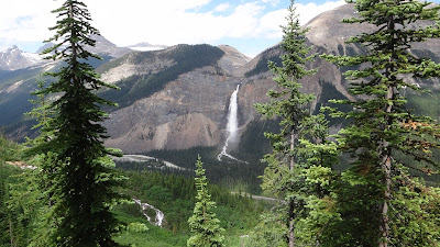
The first couple kms of the hike was pretty tiring. Just a whole lot of switchbacks until we got past the treeline. You can see the valley down below and Takakkaw Falls in the distance and even the glacier and the icefields that's feeding it, which was great.
Past the treeline, it was pretty much just hiking on rocks. At one point, the trail was about a foot and a half wide ledge on an incline. Steve made the mistake of stopping on the trail. It gave him really bad vertigo. I got pretty nervous too, but at least I had hiking poles that gave me a little bit of support and comfort. Once we got pass that little portion, Steve wasn't keen on the idea of having to go back down the same way. So, we started contemplating just doing the 17km circuit.
Anyway, I've never really had my jaw literally dropping from seeing a view until we got to the glacier. It was really amazing to see. I don't think I was expecting something like that to be waiting for me after all the switchbacks. I think the moraine was about only about a couple of kms long, but was a couple of kms of great views I've never seen in my life.
Just before you start descending to the valley, there was a little ridge we had to go over. However, part of the trail was still covered in snow. There were boot prints on the snow though, so obviously other people have made it across safely. I tried to go over the snow, but I kept on slipping. I was stupid enough to try again and I actually slipped and fell onto some loose rocks and started sliding down. It was a pretty scary experience for me. So, we were faced with two options, either backtrack across the Iceline trail and go down the way we came or try to scale the ridge through the loose rocks that didn't have snow on it anymore. Going back down the narrow ledge that we climbed earlier still made Steve a little bit nervous, so we decided to go with option #2. Turned out to be a scary option. The loose rock ended up being really loose, where we would take a couple of steps and slide back down. So once we got over the ridge, there was no changing our mind about doing the 17km circuit.
The 17km circuit ended up being the stupidest trail. Ever. It was 10km of trees. Really boring, especially when you're tired and hungry. There were a couple of things to see along the way like Lake Celeste and Laughing Falls. But it was super dooper boring. I really don't recommend doing that circuit. At all. It was very anti-climatic.
The only two interesting things you see along the way:
For the most part, the trail looked like this:
Thankfully, we made it back to camp just before dark. It was 9:30pm when we got back. I was really happy that we had real meat waiting for us in the campground, and not the dehydrated crap we eat in the backcountry. Dinner is always amazing after a tiring day.
The following morning, the weather was really nice. So after breakfast, we took out the boulder pad and started looking for some boulders we can try out. I had trouble looking for the actual boulders that were in my guide book. I'm not actually sure if I actually found them and just thought that it wasn't a good idea to try. The only boulders we could find were surrounded by a lot of other big rocks. It looks like it would make for a really sketchy landing. Since it's my first time, I really wasn't too keen on trying out bouldering outdoors in a place I wasn't comfortable with the landing area. It also started raining as we were looking for the boulders, so we really couldn't boulder anymore anyways since the rocks would be all wet and slippery.
We planned to just try out a different area the following day, but it was raining really hard on our departure day. Bouldering would have to wait for another trip :(


No comments:
Post a Comment