Wednesday, July 25, 2012

Rest of the Yoho Trip


I initially thought that Yoho National Park was about 7 hours away from Edmonton. So we decided to stay a full week in the area so we can do everything we wanted to do. It turns out it was only a 5 hour drive. I found out a week before the trip when I finally googled directions. At which point, everything for the week was pretty much set. But anyway, I'm glad we stayed for the entire week as it really gave us the chance to explore the area.

After Lake O'Hara, the second leg of our trip was Golden, BC. There's a wolf sanctuary there that Steve's been dying to go to since I met him. But since we thought it was an 8 hour drive, the trip never became a priority. The wolf sanctuary was pretty neat. We got to meat the wolf pack that was comprised of mostly rescue wolves. All of them were raised in captivity, not by the owners' doing. Most of them were orphaned at a very young age and a couple were 10% part dog which some people bred them to be pets but decided eventually that their wolf side was a little bit too much to handle once they got older. There were a couple of little orphaned wolf cubs that were at the center when we visited, and we got to hold them and take pictures with them.


This little one tried to eat my arm. They are very young though, so it didn't hurt. But it was quite amusing seeing him attempt to eat me.

After that, we just walked around town a little bit. We were both fairly tired from hiking and having to deal with the rain in the backcountry from the past four days, that we really just wanted to chill. We also missed watching television quite a bit.


After a couple of days in Golden, we headed back to Yoho National Park on Thursday morning to spend a couple of nights in Takakkaw Falls to do the Iceline Trail circuit and boulder for the first time outdoors. We were initially going to boulder on our first day out there, but when we picked up a map at the visitor center, the dude there suggested that if we wanted to do the Iceline trail, we should try to do it that day. Thursday had really gorgeous weather, and Friday was forecasted to have some rain with some chance of thunderstorms. He said it wouldn't be a good idea to be up on the Iceline trail on a downpour. So, we took his advice and headed out to the campground to set up as fast as we can so we can head out.

The campground was really nice. It was set up like a backcountry campground, yet it's still front country. They are walk-in campsites, so you're only 500m away from your car. They have little wagons there to help people load their crap from their car to camp. Most of the sites had a really good view of Takakkaw Falls. It was really nice to sleep with the sound of the waterfalls in the background and seeing it first thing in the morning when you wake up.


Anyway, we didn't finish setting up camp till almost 3pm, but we didn't want to miss out on doing the Iceline trail in the event the weather turns on us again the following day. There are three options you can take when doing the Iceline trail. The shortest one is a 12km in-and-out the same way type deal, the second one is 17km circuit that takes you down to Lake Celeste and Laughing Falls, and the last one is an even longer circuit that leads you to Little Yoho Valley. Iceline's elevation gain is approximately 700m, it was fairly steep, and the shortest option was estimated to take about 5-6 hours. Since we didn't have much time, we decided to just do the shortest option, and maybe try to do the rest of the circuit from the other direction if the weather isn't so bad the next day. Since it's in a lower elevation, we figured it might be okay in the rain.

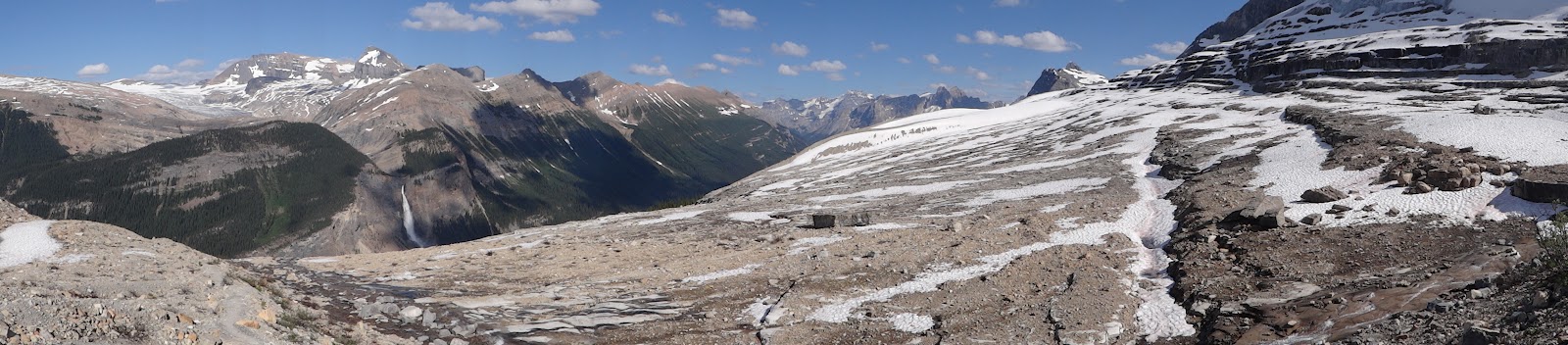
The Iceline trail is essentially a trail along rocky moraines formed by the receding Emerald Glacier. It's a fairly popular hike since you get to go pretty close to the glacier.

The first couple kms of the hike was pretty tiring. Just a whole lot of switchbacks until we got past the treeline. You can see the valley down below and Takakkaw Falls in the distance and even the glacier and the icefields that's feeding it, which was great. 


Past the treeline, it was pretty much just hiking on rocks. At one point, the trail was about a foot and a half wide ledge on an incline.  Steve made the mistake of stopping on the trail. It gave him really bad vertigo. I got pretty nervous too, but at least I had hiking poles that gave me a little bit of support and comfort. Once we got pass that little portion, Steve wasn't keen on the idea of having to go back down the same way. So, we started contemplating just doing the 17km circuit.

Anyway, I've never really had my jaw literally dropping from seeing a view until we got to the glacier. It was really amazing to see. I don't think I was expecting something like that to be waiting for me after all the switchbacks. I think the moraine was about only about a couple of kms long, but was a couple of kms of great views I've never seen in my life.


Just before you start descending to the valley, there was a little ridge we had to go over. However, part of the trail was still covered in snow. There were boot prints on the snow though, so obviously other people have made it across safely. I tried to go over the snow, but I kept on slipping. I was stupid enough to try again and I actually slipped and fell onto some loose rocks and started sliding down. It was a pretty scary experience for me. So, we were faced with two options, either backtrack across the Iceline trail and go down the way we came or try to scale the ridge through the loose rocks that didn't have snow on it anymore. Going back down the narrow ledge that we climbed earlier still made Steve a little bit nervous, so we decided to go with option #2. Turned out to be a scary option. The loose rock ended up being really loose, where we would take a couple of steps and slide back down. So once we got over the ridge, there was no changing our mind about doing the 17km circuit. 


The 17km circuit ended up being the stupidest trail. Ever. It was 10km of trees. Really boring, especially when you're tired and hungry. There were a couple of things to see along the way like Lake Celeste and Laughing Falls. But it was super dooper boring. I really don't recommend doing that circuit. At all. It was very anti-climatic.

The only two interesting things you see along the way:


For the most part, the trail looked like this:


Thankfully, we made it back to camp just before dark. It was 9:30pm when we got back. I was really happy that we had real meat waiting for us in the campground, and not the dehydrated crap we eat in the backcountry. Dinner is always amazing after a tiring day.

The following morning, the weather was really nice. So after breakfast, we took out the boulder pad and started looking for some boulders we can try out. I had trouble looking for the actual boulders that were in my guide book. I'm not actually sure if I actually found them and just thought that it wasn't a good idea to try. The only boulders we could find were surrounded by a lot of other big rocks. It looks like it would make for a really sketchy landing. Since it's my first time, I really wasn't too keen on trying out bouldering outdoors in a place I wasn't comfortable with the landing area. It also started raining as we were looking for the boulders, so we really couldn't boulder anymore anyways since the rocks would be all wet and slippery.


We planned to just try out a different area the following day, but it was raining really hard on our departure day. Bouldering would have to wait for another trip :(

Wednesday, July 18, 2012

I still need to talk about this trip. (Lake O'Hara)


Continuing on with the rest of my trip to Lake O'Hara.

The following day, it was still raining a little bit in the morning when we woke up. But since it was our last full day in the area, we just said f*ck it, let's go.

As planned, we went up to Opabin Lake. It's a short hike, and it wasn't that high. I think its 8km in total and 270m (ish) elevation gain. The first little portion of the hike wasn't too bad, we were mostly in the trees so the rain really didn't bother us too much. Luckily, the rain stopped just before we got to the steeper and semi-sketchier part of the trail. It was even a little bit sunny at some points and blue skies were peeking through the rain clouds.


This was probably my favorite trail among the three trails that we got to do. For overall scenery anyways. The views just keep on opening up. I was taking photos every 2 minutes, I just couldn't stop. The scenery really took my breath away, and I've been exploring Canada's backcountry for almost five years now and would like to think that I've seen some pretty amazing scenery. This country really never fails to surprise me. Places like these are what remind me of how I can put up with six months of winter, despite being a tropical girl at heart.


At one point, Steve was exploring this plateau that I couldn't be bothered climbing (Yes, I'm weak.). So I sat myself on this boulder facing this big meadow with a little river nestled between mountains topped with glaciers. I decided that maybe that's where I would like my ashes scattered when I die. (knock on wood) I'm sorry to taint this place with such a morbid thought. But the point is, it was really that serene. I couldn't look away from it either. It was very overwhelming.


We finally reached this huge lake which we assumed was Opabin Lake. There was a ridge in the distance, and we assumed that it was portion of the alpine circuit so we didn't bother going over it. We wanted to finish the trail before lunch time so we can set out on another hike. Satisfied that we've reached our destination, we headed back down via the East Opabin Trail (we went up the West Trail). BTW, there was a ridiculous amount of marmots and squirrels along the meadows by the east trail. A lot of them were mating too.

Hungabee Lake when I thought it was Opabin


Unfortunately, we realized when we got to the bottom that the lake we have thought was Opabin Lake, was in fact not Opabin Lake. It was another lake called Hungabee Lake. That was a really annoying feeling knowing that you were less than a kilometer away from your destination and didn't even get there. I mean, it wasn't a hard hike, but it was still 8km and almost 1,000 feet. So, we decided that we really have to go back to the area very soon. We were already bitter from not doing the alpine route since we thought that it was still snow covered, plus the shitty weather we've had the first couple of days, and then being tricked by Hungabee Lake into thinking it was Opabin Lake. 

Lesson learned, that's what happens when you don't bring a topo map on your hike. I really should never assume that a hike would be easy enough as to not require a map.

After lunch, of course it starts raining again. But we really really wanted to hike to Lake MacArthur. I've read that these are the three areas that you ABSOLUTELY MUST see if you go here. Steve suggested that we just go as far as we can, and if it starts raining really hard, we'll just head back.

(I realize we are starting to sound really afraid of the rain. Let me explain. The first night traumatized us. I got soaking wet running from the shelter to my tent. That was not pleasant.)

So we head up to Lake MacArthur. This hike was a little bit harder than the first two. Short (7km) but with an elevation gain of 413m. A lot of the elevation was in the trees too, and I really don't enjoy that too much. It's a lot easier to hike up when you have nice scenery to stare at. But I feel a lot more tired when I'm hiking in trees. There were some interesting boulders though, which made Steve and I super excited for bouldering later on that week.


It opens up soon enough to yet more amazing scenery. We were pretty high up so we got a good view of the valley down below. We made the mistake of following the "Low Circuit" which we assumed would have been easier. But no. Since we were already high up, following the low circuit meant that we hike down a few hundred feet and then have to hike back up another few hundred feet. It was very inefficient, and there was no spectacular views at the bottom either. We didn't realize it till we were at the bottom too.

Scenery from the MacArthur highline circuit


But finally, we reached Lake MacArthur, and I personally think its the most breathtaking lake among the three that we've hiked to (excluding Lake O'Hara). I almost had that morbid thought again on how this is where I want my ashes scattered. Then I realized I said that about the meadows at the Opabin trail, and felt very conflicted. I don't want my love ones to hike both trails. (I am vehemently knocking on wood right now.)


As if it was teasing us, the sun finally started shining about an hour after we got back to the campground. This really made me bitter again. We considered doing another hike just so we can take advantage of the sun. But we were already starting to feel a little bit tired. Since we did the trails separately and not via the alpine circuit, it meant that we were hiking up and down every single time, as opposed to hiking up and staying up.

We leave the following day. And since Mother Nature seems to be PMS-ing all week, of course it was nice and sunny on our departure day. We were going to take the 11:30 bus out because we were really excited to eat steak and have a real shower. But in the end, we decided that the steak and the shower can wait a couple more hours. 

So we decided to hike up to Opabin Lake again to finish the hike once and for all. We were a little bit concerned about getting back in time for the 2:30 bus. The first time we hiked the trail, we were very leisurely and it took us almost 4 hours. So we weren't really sure how long it would take us when we're not taking our time. It was almost 11am at that point. Steve figures I would not be stopping to take photos every two minutes since I've already been on the trail the day before, so we might make it back. 

I was very happy to finally see the end of the trail. Opabin Lake was really pretty too. This is what Opabin Lake looks like.

The real Opabin Lake.

Scenery from the ridge just before Opabin Lake


We actually made it back to the trailhead in just over two hours. So we had an hour and a half to kill till the bus came. We headed over to the LeRelais Day Shelter to have some of their world famous carrot cake, together with some fancy tea that my friend Ramya gave me for my birthday.


It was the perfect ending to our trip.

All in all, despite the crappy weather and the trail mistakes, it was a great trip. I am totally in love with the Lake O'Hara area.

I need to talk about this trip now. (Lake O'Hara)


"Magic mushrooms. Cannabis. Tequila. Lake O'Hara. All will get you high."

This is the first sentence written about Lake O'Hara in my guidebook. So ever since I've read about it a few years ago, I've been wanting to go. However, I never remember to book reservations on time, and this area is in very high demand. To protect the area, they limit access. There's an 11km fire road that leads to the Lake O'Hara area, but the only easy way to access it is to board a bus that Parks Canada runs. Only 42 day hikers are allowed in per day, 30 campsites, and an ACC Hut (which is almost impossible to get into since it has a very high demand that they've resorted to a lottery system). There's also a ridiculously expensive wilderness lodge that you can stay in, but those are just for fancy people and that's definitely not me. You can hike the fire road if you want. However, seems kind of silly to hike, so you can hike.

Reservations open 3 months in advance, and you're advised to call right at 8am because most of the spots are given out within the first hour. So I said, no problem I'll just set an alarm on my phone to remind me to call right away. Easy.

Not so easy. I started calling right at 8am. And kept on redialing all the way up to 8:41am before I could finally get through. This is what my phone looked like after that ordeal:


I hit the (100) call mark 20 minutes before I actually got through. I definitely made more than 100 calls. But luckily, we got to book a campsite for 3 nights (the maximum you can stay).

Anyway, on to my actual trip.

The Lake O'Hara area is absolutely breath taking. I think I may have found my favorite spot in the Canadian Rockies. All the hikes are fairly easy (as easy as alpine hiking goes anyways), and for the amount of effort you put in, the views you get are ridiculous. I think there are five main hiking areas in the region. We only got to do three of them (had to repeat one because we were stupid, but more on that later). The weather was really flaky, and we were really wussy and didn't want to get stuck in the rain while high up in the mountains. It's a struggle to dry clothes when it's constantly raining. I really wanted to be warm in the evenings.

Before I talk about the hikes, I want to talk about the campgrounds. It's the fanciest backcountry campground I've seen. Ever. I a little bit annoyed. I packed all my minimalist shit while everyone else packed in real food. I felt so deprived. Mind you, my backpacking food would have sufficed in any other backcountry situation, but it can't compare to the fresh apple that someone else is eating while I wait 8-9 minutes for my Spaghetti in Meat Sauce to rehydrate.

But for reals, the campground was really well set up. We not only had individually assigned food lockers, we also had a sink with running water, potable water, a garbage can and recycling bin, cooking shelters and firewood supply... they also had loaner items should you come in unprepared for the wilderness like extra fuel, sleeping bags, tarps, hiking poles, etc. It was a very accommodating campground. I think I may have trouble actually backpacking after this experience. I really liked having a garbage can.

The first night was really rough. We moved our incoming bus time from 5:30 to 3:30, since I realized that the drive from Edmonton is actually shorter than what I thought it would be. That proved to be a good decision. When we got to the campground, we pretty much only had time to set up before it rained torrential rain. I was super paranoid our tent would flood since I could actually feel an inch of water underneath it.

We woke up super early in the morning to start hiking. We really wanted to do the Lake O'Hara Alpine Route. The weather report that was posted in the shelter for the week indicated that it was going to be super sunny in the morning, and then thunderstorms will start rolling in mid-afternoon. Of course, it lied. It was raining till mid-morning, so we had to chill in the shelter for three hours till it stopped. Luckily, the backcountry attracts very interesting people who are not at all creeped out with conversing with strangers for hours. I really enjoy talking to other backpackers and sharing stories. I realize when we left that we've talked to so many people several times and exchanged so many stories, but I don't actually know anybody's names.

So as soon as the rain let up, we decided to skip the first leg of the alpine route and go straight to Lake Oesa. Maybe see from there if we can continue on with the rest of the alpine route if the weather isn't too shabby. We had our first glimpse of Lake O'Hara on the way since you have to hike the shoreline to get to the Lake Oesa trailhead.

This is Lake O'Hara.


Beautiful noh?

On the way there, there was a cliff face, and it was made of what looked like purple shale. I was very excited about this. I love purple. It's very hard to find shit in my purse since everything is purple. 


The trail was great. Scenery varies from being in the trees to having a birds eye view of Lake O'Hara to trekking through boulders to several pretty alpine lakes and waterfalls. Of course, Lake Oesa was breathtaking.


When we got there, we chatted with a couple on their way back down. They've decided not to do the Yukness Ledges that connects Lake Oesa to Opabin Lake since they've read in the bulletin board at the shelter that it's still winter conditions up there. Steve and I decided to do the same thing, and just head out to Opabin Lake on a separate trip since we didn't want to risk going up to the Yukness Ledges to find snow. We didn't bring our hiking poles to the hike because there wasn't very much elevation gain (only about 250m to Lake Oesa I think), but I didn't feel comfortable walking on ledges with snow on them when there's still a chance of rain later on in the day.

Of course, the bulletin board lied again. I spoke to a group of people the following morning that said there were only small patches of snow on the ledge. Very manageable though. Irritation number two. I really should stop believing the bulletin board.

It started raining again just an hour after we got out of the trail, so we didn't have time to squeeze in another hike. We just hoped for the best that the following day's weather would be better.

Anyhoo, I'm still on vacation. This was quite long. I'm leaving to do more vacation-y things now. I'll write more about the rest of the trip later.

Tuesday, July 17, 2012

Please let this be my regular return.

So I really want to start writing again, and I know I've said it many times before. It's been part of my New Years resolution every year for the past 5 years.

But over the last few months, I've realized how much I really miss writing about everything. A lot of the times I think it's mostly because I don't know what to start writing about, and I feel that the first post should always be this inspired and beautifully written piece. However, I don't think that really happens when you haven't been writing regularly for five years. Which is really odd for me, since I've kept every type of journal out there when I was growing up.

I really blame it on television. I love TV so much.

I want to start on a new slate, given the last time I blogged was about 5 years ago. I feel that this is a different era in my life. So the old blog has been moved to http://inaskidoodledone.blogspot.com

I thought that was witty. Inaskidoodle-DONE. Because it's done. Meh? Fine.

But anyhoo, I am in the middle of a week long mountain trip that's comprised of several little trips to different places. I just came out of the Lake O'Hara area last night, and am now taking a backcountry break in Golden, BC. Which means, that I'm on a mountain high. With nobody else to rave about it to aside from Steve, who is also in his own mountain high from the same trip, so I can't really rave about it to him after the fact since he was there when I was raving about it while we were on the trail. Believe me too, I went bat shit crazy on the trail. It was just amazing. I couldn't stop saying "omaygad look here, take my picture. omaygad look over there again." I think Steve really struggled to enjoy the serenity of the area because I was constantly chattering on about how serene, beautiful and peaceful it was out there, that I was really disturbing his peace.

But I'll reserve the details of that trip for a lengthier post dedicated to that. Which is why I think this is the perfect time for me to start blogging again. Because I'm on my vacation high. And it's still overwhelming me.

So I need to write it down. Release it from my system a little bit, and maybe I'll calm down knowing that I've successfully recorded the experience somewhere else.

Just kidding, I never calm down.